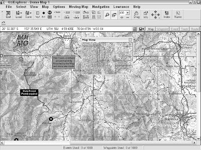
OziExplorer is a powerful and versatile mapping program developed by Des Newman. (Newman hails from Australia, and Ozi is slang for Australia — get it?). Newman originally wrote the program for personal use during four-wheeldrive trips in the Australian outback. He released OziExplorer as shareware, which has evolved into a sophisticated mapping tool that’s constantly updated.
Some of the program’s key features are that it
- Interfaces with GPS receivers: OziExplorer can communicate with just about every GPS receiver on the market, allowing you to upload and download waypoints, routes, and tracks to and from GPS receivers and PCs.
- Works in many languages: Localized versions of OziExplorer are available in a number of different languages, including English, German, French, Spanish, and Italian.
- Provides real-time tracking: If you have a laptop connected to a GPS receiver, OziExplorer displays a moving map with your real-time, current position and other travel information.
- Is easy to use: OziExplorer boasts a large number of features, such as annotating maps and extensive import and export capabilities, all of which are easy to use.
- Supports an extensive number of map formats: OziExplorer can access many popular digital map data formats (such as DRG, a Digital Raster Graphics map) and can associate georeferenced data with common graphics file types. For example, you can take a file that you created in Paint or some other graphic program and turn it into a smart map (a map where geographic coordinates are associated with individual pixels). The best way to find out about OziExplorer’s features is to download the program and try it. (OziExplorer works with PCs capable of running Windows 95 through XP.).
- Trial: The trial version is a limited version of OziExplorer that has all the program features enabled, except the program can’t
• Save or load waypoints, routes, or tracks
• Save maps as image files
• Run for more than an hour at a time
- Shareware: The shareware version has a number of features disabled and has the following limitations:
• Only two points can be used to calibrate a map, reducing the potential accuracy. (Up to nine points are available in the registered version.)
• Limited support is available for map projections, grid systems, and datums (compared with extensive support in the full version). Between these two programs available in the install package, you’ll be able to get a feel for all OziExplorer’s capabilities. And when you register the shareware version, the full monty of features is enabled. The $85 registration fee is a nominal investment considering the many features that the full version of OziExplorer offers.
If you’re looking for a street and road navigation program, OziExplorer isn’t the best choice. Ozi is more suited for adventures off the beaten path. If you need a program that helps you find the best route between two addresses on streets and highways, you’re much better off using some of the commercial mapping programs .
For more practical information on OziExplorer, including troubleshooting tips, check out the popular Yahoo! Groups e-mail list and forum devoted to the program at groups.yahoo.com/group/OziUsers-L.
In addition to OziExplorer, Des Newman also has two other related mapping programs:
- OziExplorer3D: This program is used in conjunction with OziExplorer to display maps in three dimensions. OziExplorer writes elevation data to a file, which OziExplorer3D uses to display a 3-D representation of the map. OziExplorer3D is priced at $30.
- OziExplorerCE: OziExplorerCE is moving-map software for Pocket PC (formerly known as Windows CE) PDAs. You create maps and plan trips with OziExplorer on your PC and then download the map data to your PDA to use with OziExplorerCE. When you connect your PDA to a GPS receiver, the program retrieves GPS data and displays your current location on a map. The PDA version of Ozi costs $30.

No comments:
Post a Comment