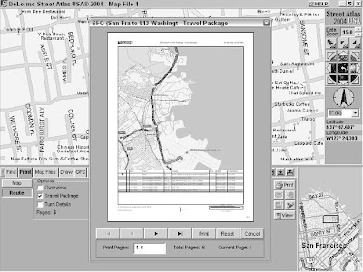
After you have a map and driving directions (read earlier sections to follow me to Sam Wo’s), you may need to make copies. Street Atlas USA has a number of options for getting the information off your computer screen and printing it to paper or saving it to a file.
To print or save maps and directions, click the Print tab. You see two buttons:
- Click the Map button for options to print or save the current map.
- Click the Route button for print and save options of the current route.
Saving and printing maps
All the Print and Save command buttons are next to the Overview Map on the
far right of the Print tab area. You have buttons for
- Printing the current map
- E-mailing the print area as an attachment
- Saving the print area to disk as a graphics file
- Copying the print area to the Clipboard If you select the Print Preview check box, the map is reduced in scale, and a rectangle is displayed around the print area.
Saving and printing routes
You can also save and print route information in a number of different formats, including an overview map with directions, turn-by-turn details, and as strip maps (detailed maps that follow a route with directions in the margins). Check the type of directions you’d like to create, using the Save and Print command buttons at the far end of the Tab area to output them. Figure shows a preview of a Travel Package, which is a format that prints the route map with directions at the bottom of the page.
If you want only a text version of the route directions, click the Route button in the Print tab and then mark the Directions check box. You can then either save the directions as a text file or e-mail them to a friend.
If you end up in Chinatown, the entrance to Sam Wo’s restaurant is through the street-level kitchen, so don’t think you’re in the wrong place. Head up the narrow stairs to the second floor and don’t disturb the cooks on your way up. Bon appétit!
