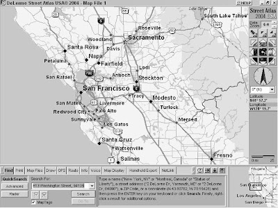
Knowing the address of someplace and where it’s located is a start, but getting there in a timely fashion without getting lost or frustrated is the true test of a driver (or his or her navigator).
One of the benefits of street navigation software is that it can automatically generate a route between two or more points. The software examines the roads between your starting point and destination, measuring distance and factoring in speed limits to select either the shortest or fastest route. Street navigation software can give you only its best guess when it comes to a route. A program can’t account for new roads that were built after the map data was compiled or local traffic patterns. You’ll probably be able to find faster and more direct routes in cities based on your own local knowledge and experience. Although routes from software might not always be perfect, they’re much more accurate than guessing or driving around aimlessly.
Street Atlas USA has a number of powerful options for creating routes. To give you a better idea of how route finding works, start off simple.
Sunday, January 31, 2010
Finding an Address with Street Atlas USA

Whenever I’m in San Francisco, I always try to visit Sam Wo’s, my favorite authentic, Chinese noodle joint, located smack-dab in the middle of Chinatown. Anytime I hear about friends or acquaintances heading to San Francisco, I always tell them to head downtown and check out this famous Chinese fixture. It’s been around for 100 years, Kerouac and Ginsberg hung out there, and it was home to arguably the rudest waiter in the world. If you don’t know San Francisco, finding this restaurant can be challenging. And even if you can get around the City by the Bay fairly well, giving precise directions to visitors can also be a little demanding. This is where street navigation programs like Street Atlas USA really shine. As an example of finding a location and creating a map to get to it, here’s how to find Sam Wo’s restaurant:
- Click the Find tab and then click the QuickSearch button. You can perform several different types of searches, but this is a simple QuickSearch. (I talk about Advanced searches and Radar in a minute.) The Find tab options and commands are shown in Figure.
- In the Search For text box, enter the address you want to find. Sam Wo’s restaurant is located at 813 Washington Street, 94108. You can enter the city and state along with the address, but if you know the ZIP code, it’s quicker and easier to use it instead.
- Click the Search button. Street Atlas USA searches through map and street data; if the address is valid, a map of the location is displayed. In this case, Sam Wo’s is exactly where I remembered it to be.
- Advanced searches: As the name suggests, this option performs more detailed, advanced searches. You can search by categories (such as rest areas, schools, and parks) as well as specify searches take place within a certain area (such as a ZIP code, county, or the current displayed map).
- Radar searches: This is cool feature that lets you search for travelrelated POIs within a certain distance of the current center of the map — or if you’re using a GPS receiver with Street Atlas USA, from your current location.
Getting POI information

Getting Point of Interest information from Street Atlas USA is a snap.
Here’s how.
When you zoom in to level 15, you start to see POIs on the map, such as restaurants, gas stations, theaters, hotels, and other businesses and services. At Zoom Data level 16, symbols appear that let show you what the POI is. For example, a plate with a fork and knife means a restaurant. If you don’t know what a symbol means, click the HELP button in the window title and choose Map Legend from the menu to display a list of all the map symbols and their meanings.
When you move the cursor over a POI, the business or service name, its phone number (if available), and the type of POI are shown at the bottom of the map. You can also get more information about a POI (or any map feature) by moving the cursor over the POI, right-clicking, and choosing Info from the pop-up menu. Information about the POI appears in the Tab area, which you can view by clicking the Info tab, as shown in Figure. Don’t treat the POI database like an up-to-date phone directory. If you look up restaurants, gas stations, and other businesses in your city, you’ll probably find a few listed that are out of business and others that are missing. DeLorme and other map companies try to keep POI data as current as possible, but because businesses come and go so often, it’s difficult to keep up with all the changes.
Subscribe to:
Comments (Atom)
